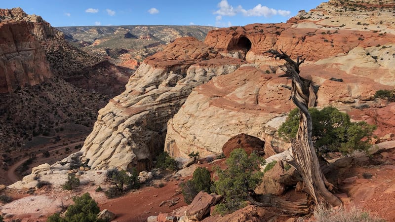
PARKS Atlas
A hiker with a blue backpack and red jacket stands on a red sandstone ledge overlooking a sweeping canyon landscape at Capitol Reef National Park, with cloud-filled skies and warm afternoon light illuminating the layered cliffs.

Utah · National Park · Trails

Hiking in Capitol Reef

Canyon floors and high ridges — check the forecast for the washes, carry water for the climbs.

Capitol Reef National Park · Hiking in Capitol Reef National Park

Map

Explore Capitol Reef

Explore more

Trails

The trails worth your time in Capitol Reef

Capitol Reef's trails split between the canyon floors and the high ridges, and the split decides your day. The canyon routes — the level Grand Wash and the Cassidy Arch climb above it — run through flash-flood-prone washes, so check the forecast before you start. The ridge hikes (Chimney Rock, the long climb to Navajo Knobs) trade shade for wide views over the Waterpocket Fold and get hot and exposed by midday. They run from the short family walk to Hickman Bridge to an all-day summit push — pick by how much climb and exposure you want, and start early in summer either way.

A historic pioneer farmstead with a rustic wooden barn and fenced pastures sits beneath towering red sandstone cliffs in Capitol Reef National Park, Utah.

Hickman Bridge

4.7 (10,563)

1.8 mi +416 ft gain 1–1.5 hr

Moderate Out & back

The park's signature trail — a short climb through Kayenta sandstone to a 133-foot natural bridge spanning a side canyon. The trail also passes a small Fremont granary tucked into a cliff alcove. Best in morning light when the bridge glows orange against blue sky.

A historic pioneer farmstead with a rustic wooden barn and fenced pastures sits beneath towering red sandstone cliffs in Capitol Reef National Park, Utah.

Cassidy Arch

4.8 (6,838)

3.3 mi +662 ft gain 1.5–2.5 hr

Moderate Out & back

Named for Butch Cassidy, who allegedly hid in the canyons below. Steep switchbacks out of Grand Wash lead to a slickrock ridge where you walk on top of the arch itself — a 50-foot span over a 400-foot drop. Not for the height-averse, but the view down Grand Wash is the reward.

A historic pioneer farmstead with a rustic wooden barn and fenced pastures sits beneath towering red sandstone cliffs in Capitol Reef National Park, Utah.

Grand Wash

4.7 (5,280)

4.8 mi +341 ft gain 2–3 hr

Easy Out & back

A flat walk through a narrow canyon where Wingate sandstone walls close to 16 feet apart. The narrows section is the draw — Capitol Reef's answer to Zion's slot canyons, without the permit or the crowds. Flash flood risk is real; check weather before entering.

A historic pioneer farmstead with a rustic wooden barn and fenced pastures sits beneath towering red sandstone cliffs in Capitol Reef National Park, Utah.

Chimney Rock Loop

4.8 (3,204)

3.6 mi +797 ft gain 1.5–2.5 hr

Moderate Loop

A loop that climbs from the highway to a ridge above the Chimney Rock spire, then traverses the mesa top with views across the Waterpocket Fold. The climb is steady but never technical. Go early — the south-facing slope bakes by midmorning and there is zero shade on top.

A historic pioneer farmstead with a rustic wooden barn and fenced pastures sits beneath towering red sandstone cliffs in Capitol Reef National Park, Utah.

Navajo Knobs

4.8 (1,654)

9.2 mi +2,145 ft gain 4–6 hr

Strenuous Out & back

The longest and most exposed trail in the Fruita area — follows the Rim Overlook route past its terminus and continues along the slickrock rim to a 360-degree viewpoint above Halls Creek. The final mile is cairn-following across bare rock. Carry more water than you think you need; there is no shade and no bailout.

Sulphur Creek

6.1 mi 482 ft gain

Moderate Point to point

Sulphur Creek is a river-canyon route, not a maintained trail, so you wade the creek and scramble down a few small waterfalls and pour-offs along the way (expect wet feet, and bring a swimsuit). Most people hike it one-way, top-down, which means it is point-to-point and needs a short car shuttle between the two trailheads. The park moved the official start to a pullout 0.25 miles west on the south side of Highway 24. This is a narrow canyon and it is flash-flood prone, so never enter if rain is in the forecast.

Golden Throne Trail

4.1 mi 1,062 ft gain 2.2 hr

Moderate Out & back

The Golden Throne Trail climbs from the foot of Capitol Gorge, winding up between narrow canyon walls toward cliffside views of the Golden Throne, a Navajo sandstone dome capped by Carmel sandstone above the Utah desert. To reach it you drive Scenic Drive to its end, then follow the unpaved Capitol Gorge spur road just under 2 miles to the trailhead. The route is steady, hot, and exposed with limited shade, so start early and carry plenty of water.

Strike Valley Overlook Trail

6.4 mi 413 ft gain 2.3 hr

Easy Out & back Kid friendly

The classic view of the Waterpocket Fold — a tilted 100-mile wall of rock seen end-on from the rim. The overlook walk itself is short, but the trailhead sits at the end of the Burr Trail switchbacks on a high-clearance dirt road; check conditions and don't attempt it in a low car or after rain.

Trail data powered by AllTrails. Save offline maps, see live conditions, and download GPX tracks with AllTrails+.

Capitol Reef trail conditions alerts

One email when smoke, storm, or fire affects Capitol Reef trail access. Trail-specific — not the same as our lodging alerts.

Save on Entry

One pass covers Capitol Reef — and every other US national park.

The America the Beautiful annual pass pays for itself in two or three park visits. Free entry, free passenger fees, and no more fumbling for a credit card at the kiosk.

America the Beautiful National Park Pass — the 2026 annual pass card Buy your pass → Learn more about the pass

Ships from US Park Pass. Free shipping in the continental US.